产品描述
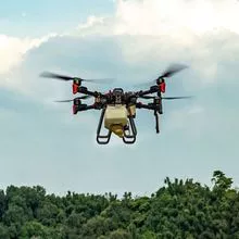
GS-800 multi-rotor UAV aerial photographing and mapping system is made of high-strength carbon fiber, with
novel and lightweight fuselage design, smart, stable, flexible, and low noise. It supports simulated flight, long
flight time, suitable for operation in cities, towns and mountainous areas.
GS-800 multi-rotor UAV aerial photographing and mapping system, simple to operate and convenient to
transport, can carry out simple and stable flight without too much technical training. It is widely used in geological exploration, remote sensing mapping, environmental protection, meteorological exploration, disaster monitoring, aerial survey, line and pipeline inspection, urban patrol and so on.
Application
Small and medium-sized mapping, aerial mapping, aerial monitoring, power planning and design, land survey,
forestry application, earthquake relief and other industries.
High Efficiency
Endurance without payload ≤ 85mins Endurance with GS-100M+ ≤ 65mins
Endurance with GS-00C+≤ 50mins Endurance with GS-30X/GS-260X≤ 40mins
Easy Operation
Support simulated flight and adapt to mountain operation
Support to import KML and accurately plan the survey area
Automatic figure 8 flight, coordinated turn
Special Safety
Aircraft self inspection protection and pre flight inspection protection to avoid misoperation
Automatic return with low power, automatic return with broken chain and no fly zone are set to
reduce potential safety hazards
Magnetic compass abnormal protection, attitude protection and broken propeller protection
provide escort for safe operation
- 无人机
- 无人及配件
- 雷达
- 硬件
- 导航
- 监测
- 发动机
- 螺旋桨
- 红外线
- 摄像头
产能:
未通知
运输时间表:
根据订单的规模
Incoterms:
未通知包装明细:
未通知
更多关于
Shenzhen Nuobashi Trading Co.,Ltd
10-50
员工
未通知
100%
% 出口销售额
Year
成立年份
业务类型
- Industry / Manufacturer
- Distributor / Wholesaler
关键词
- 半导体
- 汽车诊断仪
- 无人机
- 示波器
- 电子元器件
联系方式和位置
-
Weili ********
-
+86 1********
-
深圳 / | 中国

